Improving Space Situational Awareness
Orbital debris and orbital crowding mean that owners and operators of satellites and spacecraft need information on the objects orbiting nearby in order to avoid collisions like that experienced between Iridium 33 and Cosmos 2251. Several States and satellite owner-operators monitor the location of objects in space, but only in limited ways—the "big picture" is not fully known by all.
The most robust understanding of the near Earth space environment is obtained by the United States military's Space Surveillance Network, which tracks about 22,000 man-made objects in Earth orbit (as of 2012). Because of national security sensitivities, the United States has been reticent to allow owner-operators around the world to tap the information, although it does provide some services to share SSA information and to provide warnings of potential collision to satellite operators throughout the world. In order to enable many safety and sustainability initiatives to be effective, a certain amount of orbital data will need to be available to all users of Earth orbit.
Concerned about satellite operational safety and reliability, satellite communication companies Inmarsat, Intelsat, and SES in 2010 formed a non-profit entity called the Space Data Association (SDA) to provide services to participating operators for collision warning and mitigating radio frequency interference. Today, both private and governmental satellite operators responsible for more than 300 operational satellites in both LEO and GEO are members. Each member satellite operator contributes information on the positions and other aspects of its satellites to the SDA, which in turn provides operators with operational data critical to safe and efficient satellite operations.
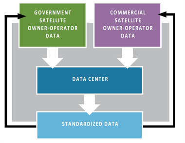 A diagram of the SDA's Space Data Center, courtesy SDA
 Share
Share